Overview
Raksirang Rural Municipality (Raksirang Gaupalika), Makwanpur, Bagmati Pradesh, Nepal
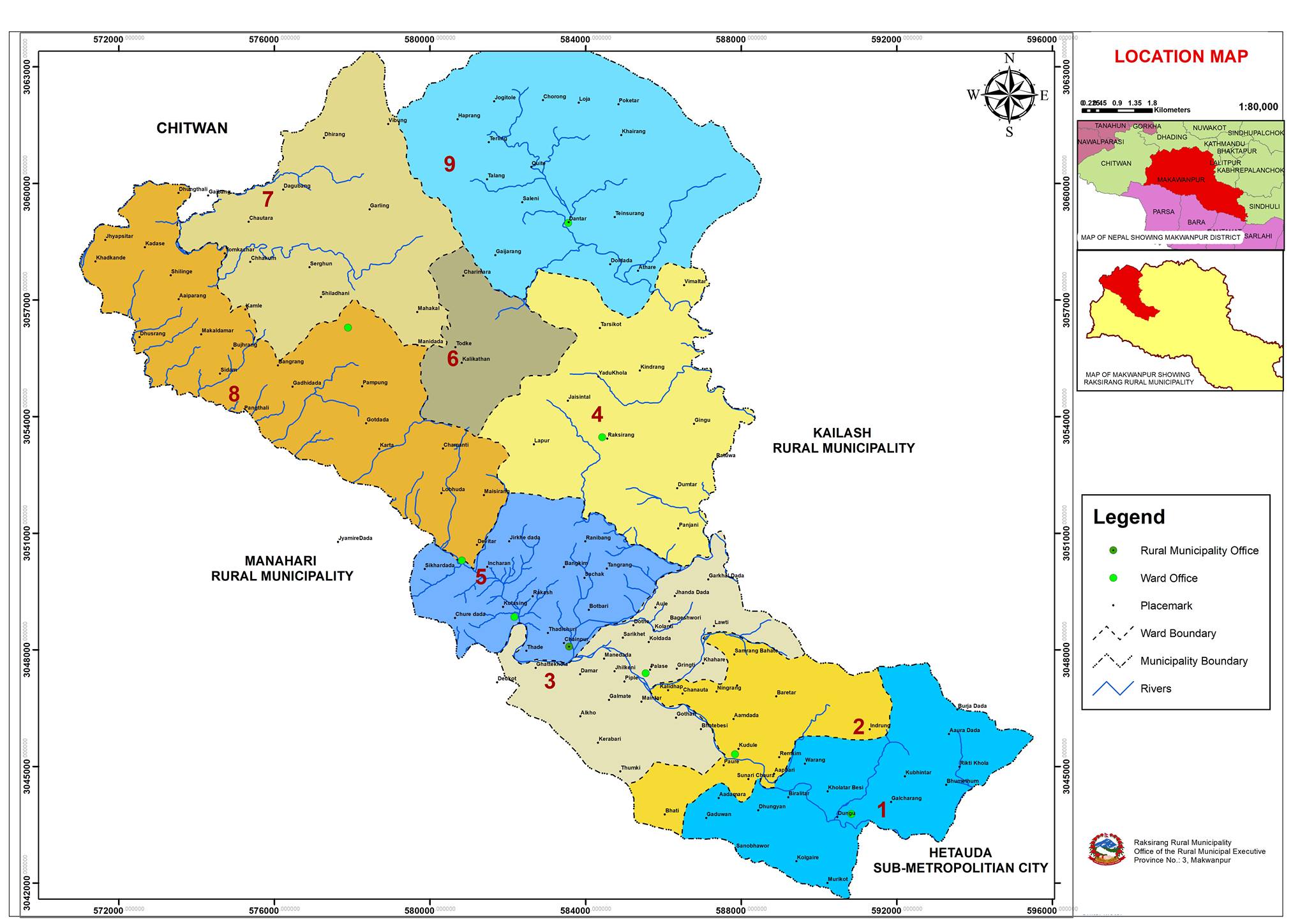
Raksirang Rural Municipality, locally known as Raksirang Gaupalika, is a rural administrative division situated in the western and northern parts of the Makwanpur district in Bagmati Pradesh, Nepal. This municipality was officially formed on 27th February 2017 (2073-11-27 BS) following the decision of the Government of Nepal. It was established by merging four former Village Development Committees (VDCs): Kankada, Raksirang, Sarikhet, and Khairang.
Geographic and Demographic Overview
Raksirang Rural Municipality covers an area of 226.7 square kilometers. According to the 2078 BS census, the municipality has a total population of 25,996, while a household survey conducted in 2075 BS recorded a population of 30,830. The population density stands at approximately 135.72 people per square kilometer. The municipality is bounded by Hetauda Sub-Metropolitan Municipality and Kailash Rural Municipality to the east, Rapti Municipality of Chitwan District to the west, Manhari Rural Municipality to the south, and Kailash Rural Municipality and Benighat Rorang Rural Municipality of Dhading District to the north.

The municipality is divided into nine wards, with the municipal center located in Chainpur-5, Raksirang. The majority of the population comprises the Tamang ethnic group (46.25%), followed by the Chepang (43.96%), Chhetri (2.75%), Dalit (2.38%), Magar (1.5%), Newar (0.56%), and Brahmin (0.06%) communities. The literacy rate in the municipality is 70.2%, as recorded in the 2078 BS census.
| Current Ward no | Included Former V.D.C | Area in sq.km | Population | Family no |
| 1 | Sarikhet 8 & 9 | 21.63 | 2184 | 469 |
| 2 | Sarikhet 6 & 7 | 15.35 | 2158 | 461 |
| 3 | Sarikhet 1,2,3,4 & 5 | 20.51 | 3637 | 811 |
| 4 | Raksirang 1,2,3,4,5,6 & 7 | 30.72 | 2662 | 541 |
| 5 | Raksirang 8 & 9 | 18.14 | 2848 | 538 |
| 6 | Kankada 1 & 5 | 10.33 | 3124 | 562 |
| 7 | Kankada 6,7,8 & 9 | 35.55 | 3288 | 551 |
| 8 | Kankada 2,3 & 4 | 34.32 | 2706 | 483 |
| 9 | Khairang 1,2,3,4,5,6,7,8,9 | 40.15 | 3389 | 628 |
| Total | 226.7 | 25996 | 5044 |
Infrastructure and Development
Road infrastructure in Raksirang Rural Municipality remains a critical area of focus. Despite being a fundamental aspect of development, all roads within the municipality are currently unpaved. The local government has prioritized upgrading these roads with plans to gravel and eventually blacktop them. This initiative aims to enhance connectivity and support the overall development of the area. The construction of other infrastructure projects is also underway, although the diverse geography and climate pose challenges to timely implementation.
Climate and Topography
Raksirang's geography spans altitudes ranging from 300 meters to 2300 meters above sea level, resulting in a diverse climate. The municipality experiences a temperate monsoon climate, with hot summers and mild winters. The average annual temperature is approximately 27 degrees Celsius, with summer temperatures reaching up to 35 degrees Celsius and winter temperatures dropping to a minimum of 5 degrees Celsius. The region receives an average annual rainfall of 2200 milliliters, primarily during the monsoon months of May to August.
The climate varies significantly across the municipality, with the valleys experiencing a hot climate, the hilly regions a temperate climate, and the higher elevations of the Mahabharata range a cooler climate. This variation in climate influences the agricultural practices and lifestyles of the local population.
Agriculture and Economy
Agriculture is the predominant occupation in Raksirang Rural Municipality. The fertile land, though limited in arable area due to the hilly terrain, supports the cultivation of various crops and vegetables. Traditionally, the locals have relied on organic farming methods, but the scarcity of organic manure has led to the increased use of chemical fertilizers. Irrigation facilities are limited, further constraining agricultural productivity.
The region's economy is largely dependent on subsistence farming, with efforts being made to improve agricultural practices and infrastructure to support the livelihoods of the local population.
Administrative and Contact Information
Raksirang Rural Municipality is governed by a rural executive body located at Chainpur-5, Raksirang. The geographical coordinates of the municipality are 27°32’53.19” North latitude and 84°50’39.13” East longitude. The Google Plus Code for the municipality is GRXV+6MW. The office PAN number is 201360479.
Conclusion
Raksirang Rural Municipality, with its rich cultural heritage and diverse population, represents a region with significant potential for growth and development. The local government is committed to enhancing infrastructure, particularly road networks, to improve accessibility and support economic activities. Despite the challenges posed by its geographical and climatic diversity, Raksirang is poised for gradual development, driven by the resilience and determination of its people.


