Overview
According to the administrative division of Nepal, Panchpokhari Thangpal Rural Municipality (पाँचपोखरी थाङपाल गाउँपालिका, सिन्धुपाल्चोक) belongs to the Sindhupalchok district under the Central Development Region and currently belongs to Bagmati Pradesh. Panchpokhari The name of Panchpokhari Thangpal Gaupalika is associated with the famous religious and tourist site Panchpokhari. This village municipality was established in 2073 BS along with the restructuring of the Province. Panch Pokhari Thangpal Rural Municipality is divided into 8 Wards and the headquarters located in Thangpaldhap.
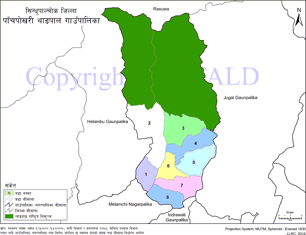
Jugal Gaupalika in the east, Helambu Gaupalika in the west, Rasuwa, and Langtang National Parks in the north and Melamchi municipality in the south. The naming site of this rural municipality, Panchpokhari, belongs to the national park within the geographical area of ward no. 3 Bhotang of this rural municipality. The total area of this municipality is 187.29 sq. Km. At an altitude of 4100 m above sea level, the upper part of the municipality is Panchpokhari.
As per the decision of the Government of Nepal, Panchpokhari Gaupalika was declared by including former VDCs Banskhark, Baruwa, Bhotang, Thangpalkot, Gunsa, Thangpaldhap, Bhotenamlang, and Lagarche. Adequate availability of natural resources such as forests, fertile agricultural lands, river channels, and biodiversity, increase in educated human resources, availability of demographic dividends, operation of educational training centers, availability of tourist destinations, an abundance of valuable herbs and famous places of religious significance. Being the cornerstone of sustainable development of this village municipality Are in the form. This village municipality is inhabited by people of different castes and religions.
According to the background survey 2075, the total number of households in this municipality is 7,803. There are 16,964 females and 17,733 males. According to the Household Survey 2075, the highest number of 4650 households (59.59%) of Tamang caste, 973 households of Chhetri caste (12.49%), 524 households of Dalit caste (6.71%) came second. In the fourth, Newar caste 457 households (5.87%), other castes 291 households (3.73%), Holmo caste 228 households (2.92%), Gurung caste 197 households (2.52%), Sherpa caste 161 households (respectively). 2.06%), Brahmin caste 157 households (2.01%), Bhujel caste 90 households (1.15%), Danuwar caste 55 households (0.70%), and Magar caste 20 households (0.25%). Are living.
Geographical Map of Panch Pokhari Thangpal Rural Municipality:
Contact Address:
Location: Thangpaldhap, Sindhupalchok, Bagmati Pradesh, Nepal
Telephone: +977-1-6227201
Email: [email protected]
Website: www.panchpokharithangpalmun.gov.np


